Boothill Graveyard


REGISTRATION:

No date has been scheduled for this event.


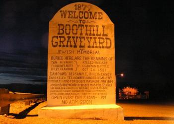
Tombstone, Tucson start
600 km Brevet

  • Date/Time
  • Description
  • Directions
  • Route Map
  • Cue Sheet
  • Elevation/Terrain
  • Requirements
  • Rider Info
  • Registered Riders
Date:  Thursday, April 3, 2014

Distance: 373 miles

Start Time: 05:00
There will be a mass start at 5 AM and announcements at 4:45.

Start Location: Starbucks on W Cortaro Farms Rd, Tucson (Get directions)

Time Limit: 40 hours

Sunrise:  6:10 AM
Sunset:  6:45 PM
Moonrise:  5:25 PM, previous day. Waxing gibbous with 100% of the Moon's visible disk illuminated.
Moonset:  5:42 AM Saturday

Cost: $60

ACP sanctioned.

WAIVER NOTE: You will be automatically directed to the online waiver after you submit your PayPal payment. If you are not automatically directed to the online waiver after your pay, you may press the "Return to Merchant" button to sign the waiver. The online waiver may also be found at tinyurl.com/AZBrevetWaiver.

REGISTRATION NOTE: Once you are registered for a ride, you will see your name in the Registered Riders tab. It may take a day or so for it to appear. Registered riders WILL be sent a "Last Minute Notes" email the day after registration closes, normally the Thursday before the ride. If you do not receive it, please let me know. Also, check your spam folder for the email.

RIDE VERIFICATION: All of these events are sanctioned by Randonneurs USA (RUSA). As such, all of them will be verified using approved RUSA methods. Click HERE to see the details of available options for AZ Radonneurs' events.

Description


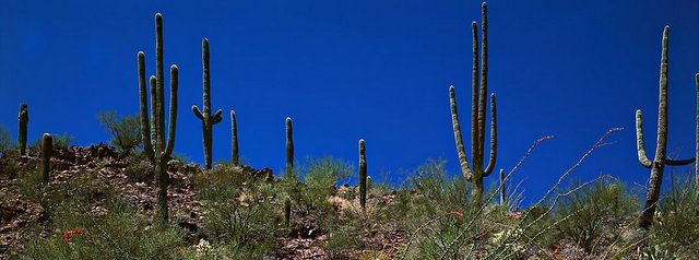
Saguaro National Park under beautiful Arizona blue skies!

Blow by Blow: First off, we'll climb Gates Pass (the easy way) in Saguaro National Park - a virtual saguaro and cactus forest. After that we're only on the streets of Tucson for a short time before heading south to the border town of Arivaca, home to the
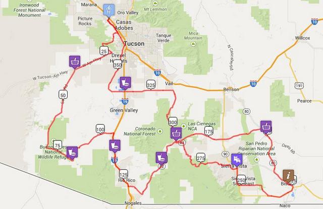
 Buenos Aires Wildlife Refuge.

After leaving Arivaca, we'll head further south through Tumacácori National HIstorical Park on our way to Nogales. Before we get to the border, we'll head back north and ride through the self-proclaimed "quirky" town of Patagonia. This is a natural riparian area between the Santa Rita and Patagonia Mountains. Our contol is located here so we'll have the opportunity to enjoy some of the local flavor.

At this point we'll be entering the high desert wine region of Southern AZ. Elevations will stay between 4000' to a maximum of 6000' in Bisbee. Springtime temperatures should be very pleasant during the day and can be quite cool/cold after dark. The desert cools down very quickly as the sun sets. Winds can also be a friend or foe depending on one's direction of travel.

The old west town of Tombstone will be our next destination and control. If you have some time in the bank, you can visit Allen Street. Allen Street is one of the most notorious streets in the old west and is alive and well. Throughout the past 140 years it has survived two major fires, the loss of the mining industry, and countless violent encounters. Each year many thousands of visitors walk where old west heros and villains lived, worked and fought. From boomtown to bust this little city earned its nickname, "The Town Too Tough To Die". If you arrive before 5 pm, you'll see people dressed in period clothes and stagecoaches. There are even public hangings on special occasions.

After Tombstone, we'll head to Bisbee. Today Bisbee has evolved into an attractive artist colony and retirement community, known for its relaxed quality of life. Travelers from all over the world come to Bisbee to savor its unique charm. Bisbee is also home to one of the BEST (my opinion) boutique coffee roasters anywhere, Old Bisbee Roasters. If you're up for a fantastic brew (and at 220 miles into the ride who wouldn't be) stop by "Peddler's Row" in downtown Bisbee and Seth will supply you with your fix. You'll want to be able to stay awake to get to the overnight stop in Sierra Vista, some 40 miles distant.

After the overnight stop in Sierra Vista, you'll ride through the US Army base of Fort Huachuca. Make sure you have a photo ID or passport. Otherwise, you will not be allowed onto the base. You're going to love riding through here! Low traffic, low speeds, polite drivers, great scenery, and maybe even a few little hills. Once you exit the Fort, you will be mostly descending for the next 100 miles... mostly.

The only impediment to your descending bliss and quick return to Tucson will be an 800' 2% climb out of Green Valley. Your penultimate control will be located just before this climb so you'll be able to fuel up for the quick dash to the finish.


Directions to the start

Location: Starbucks on W Cortaro Farms Rd, Tucson

Address:

Starbucks / Walmart Parking lot at:

5970 Arizona Pavilions Dr, Tucson, AZ 85743

Click here for a map to the start.

Directions:  Take I-10 to Cortaro Rd in Tucson. Go east for about 0.2 mile to Starbucks / Walmart Plaza

There are multiple lodging options about 1/4 mile from the start.

Lodging in the area: View List


Route Map

View  RWGPS online map here


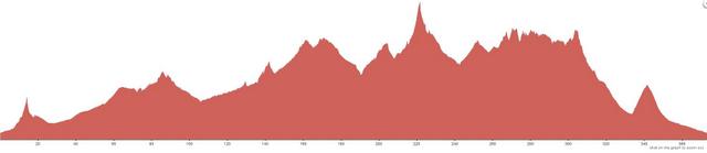
Cue sheets may be downloaded and printed by riders if they wish. Cue sheets will NOT be passed out at the start. Make sure you have a cue sheet as a backup in case your GPS fails.

Download cue sheet (xls)

Download cue sheet (pdf)

Elevation Profile

Approx 14,000 feet of accumulated elevation gain

Minimum/maximum elevation: 2160 / 6000 feet above sea level.


Requirements

Lights: Required. There will be a light inspection at check-in to verify front and rear lights are working and are sufficient for night riding. Also required are reflective vest or sash and ankle reflectors.

Hydration System: Much of the route is very remote with no services. Check the cue sheet carefully to determine how much water you need to carry to get you to the next water hole.

Services

Services TBD

Rider limit: 75 riders

0 Registered Riders.

No registered riders at this time.