Home of Arizona Brevets and Long Distance Cycling
|
Owl Head Buttes REGISTRATION: No date has been scheduled for this event. |
| Owl Head Buttes |
||||||||
Date: Wednesday, March 25, 2015
Distance: 125 miles Start Time: 7:00 am Time Limit: 13.5 hours hours Sunrise: 6:21 AMSunset: 6:39 PM Cost: $15 All riders must pre-register. (No day of event registration.) RUSA sanctioned. WAIVER NOTE: You will be automatically directed to the online waiver after you submit your PayPal payment. If you are not automatically directed to the online waiver after your pay, you may press the "Return to Merchant" button to sign the waiver. The online waiver may also be found at tinyurl.com/AZBrevetWaiver. REGISTRATION NOTE: Once you are registered for a ride, you will see your name in the Registered Riders tab. It may take a day or so for it to appear. Registered riders WILL be sent a "Last Minute Notes" email the day after registration closes, normally the Thursday before the ride. If you do not receive it, please let me know. Also, check your spam folder for the email. RIDE VERIFICATION: All of these events
are sanctioned by Randonneurs USA (RUSA).
As such, all of them will be verified using approved RUSA
methods. Click HERE
to see the details of available options for AZ Radonneurs'
events. Description
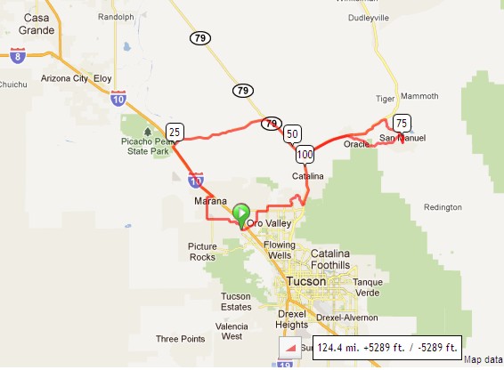
The route starts in Marana and heads north on the I-10 frontage road before turning east on Park Link Road. Park Link Road has recently been paved, and offers little traffic, and a beautiful Sonoran Desert landscape Park Link Road ends at AZ 79/Pinal Parkway, where we head south. Before reaching Tucson, we turn east to the town of Oracle. The turnaround is in the town of San Manuel. Being a brevet, riders must collect proof of passage in San Manuel which may be a receipt from a store, ATM, or restaurant. After the turnaround, riders will experience Webb Rd, another quiet and recently paved desert road. Then the route heads south on Oracle and Tangerine. Directions to the start Location: Twin Peaks Rd, Marana Address: Intersection at Twin Peaks Rd and Silverbell Rd, southeast corner Directions: From I-10: Get off I-10 in Marana, at Twin Peaks Rd Exit 244/245. Follow Twin Peaks Rd in a SW direction for 1.7 miles. The brevet start is at the intersection of Twin Peaks Rd and Silverbell Rd, SE corner, where you will see the Safeway store on your left.Google map: Click here
Cue sheets may be downloaded and printed by riders if they wish. Cue sheets will NOT be passed out at the start. Make sure you have a cue sheet as a backup in case your GPS fails. (PDF format is not yet available.) Elevation Profile
5,300 feet of elevation gain - but much of this is at around 2% grade. Requirements Riders are expected to do simple repairs such as repair a flat tire. Lights: Optional. However, if you're still riding after sunset, you need lights as required by law. Services Mile 0: Bathroom and coffee at the start at Rock n Java Cafe. Mile 13: Circle K in Marana. No services next 40 miles. Mile 52: Roadside station with food and snacks on AZ-79/Pinal Parkway Mile 76: Mini Market & Subway sandwich shop Mile 103: McDonald's in Catalina Mle 107: Convenient store on the corner of Oracle & Rancho Vistoso. 1 Registered Riders.
|