Home of Arizona Brevets and Long Distance Cycling
|
Rosevelt Lake at the dam. (Photo courtesy Tom Baker.) REGISTRATION:
Registration is closed or not yet open. |
| Mines to Pines |
||||||||||||
Date: Saturday, April 27, 2013
Distance: 135 miles Start Time: 7:00 am Time Limit: 13.5 hours Sunrise: 5:39 AMSunset: 19:03 Moonrise: 8:25 p.m. on preceding day. Then moonset at 7:05 am. Moonrise again 9:31 p.m. on brevet day. In other words, moon light will not be available during this event. Moonset: 7:05 a.m. Cost: $30 RUSA sanctioned. WAIVER NOTE: You will be automatically directed to the online waiver after you submit your PayPal payment. If you are not automatically directed to the online waiver after your pay, you may press the "Return to Merchant" button to sign the waiver. The online waiver may also be found at tinyurl.com/AZBrevetWaiver. REGISTRATION NOTE: Once you are registered for a ride, you will see your name in the Registered Riders tab. It may take a day or so for it to appear. Registered riders WILL be sent a "Last Minute Notes" email the day after registration closes, normally the Thursday before the ride. If you do not receive it, please let me know. Also, check your spam folder for the email. RIDE VERIFICATION: All of these events
are sanctioned by Randonneurs USA (RUSA).
As such, all of them will be verified using approved RUSA
methods. Click HERE
to see the details of available options for AZ Radonneurs'
events. Description
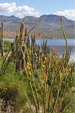
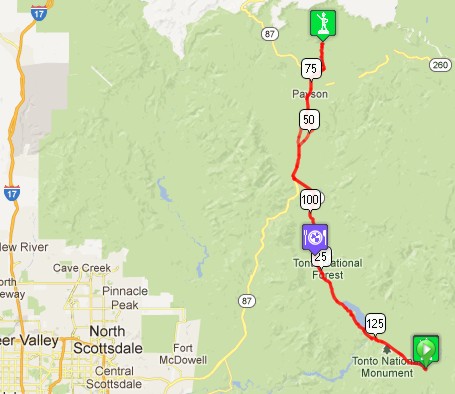
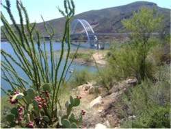
Mines to Pines covers a range of climates and diverse scenery on good roads. The ride starts at the Spring Creek Store on Hwy 188 and travels along the length of Roosevelt Lake. The store is located about 10 miles south of Roosevelt Dam (AZ 88) on Hwy 188 and 18.8 miles north of US 60 in Globe. After traveling on Hwy 188, the route then follows SR87, the Beeline Hwy, up Oxbow Hill to Payson. Just north of Payson, the route goes out Houghton Mesa Rd in the pines. The turnaround is at the First Crossing Campground, with the return following the same route back to the Spring Creek Store. Rider information for 2013 This brevet is definitely more challenging than the Around the Bend 400k brevet in terms of a long climb to Payson. Total climbing is 8350 feet. See the Elevation/Terrain tab for more details. Directions to the start Location: Spring Creek Store Address: Hwy 188 on Lake Roosevelt Directions: The store is located about 10 miles south of Roosevelt Dam (AZ 88) on Hwy 188 and 18.8 miles north of US 60 in Globe.Park to the north of the store in the open lot.
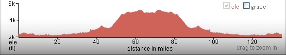
Cue sheets may be downloaded and printed by riders if they wish. Cue sheets will NOT be passed out at the start. Make sure you have a cue sheet as a backup in case your GPS fails. (PDF format is not available.) Elevation Profile Total climbing 8350 ft! Take note of the route profile as the climbs on this ride are not rollers, but long, steady climbs. This ride passes through several climate zones from 2200 ft at the lake to over 5200 ft elevation in the pines.
Requirements Riders are expected to do simple repairs such as repair a flat tire. Lights, safety vest/belt, and ankle bands are required when riding after dark. Services Start/ Finish for the 200k is at the Spring Creek Store on Hwy 188 below the Salt River Pass climb. Checkpoint #2 is at the Tonto Basin Market. Tonto Basin Market is a full grocery store with a deli, pizza & ATM. This is the primary place for food along Hwy 188. Tonto Basin Market closes at 8 pm this year. Butcher Hook Store and Restaurant is farther back from the road than the gas station. The store has a good selection of food, even bananas sometimes. Jake's Corner Store has minimal food. You won't be feasting here, but it may be a life saver if you bonk. Better to plan on Tonto Basin Market. Highway Rest Area at junction of AZ 188 and US 87 has NO water or rest rooms this year. Checkpoint #3 at First Crossing Campground on Houghton Mesa Rd. Checkpoint #4 Tonto Basin Market closes at 8 pm. This is a key place to plan on stopping for food and water as it is a full grocery store with deli and ATM. Checkpoint #5 Spring Creek Store at mile 135 (finish) closes at 9 pm. Tom Baker is your trail boss for this ride. cell phone 602 309-3768 2 Registered Riders.
|