Arizona Brevet & Randonnee
Home of Arizona Brevets and Long Distance Cycling
|
|
| 600 km Brevet - Tombstone |
|
Date: Saturday-Sunday, April 13-14, 2013
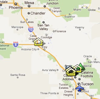
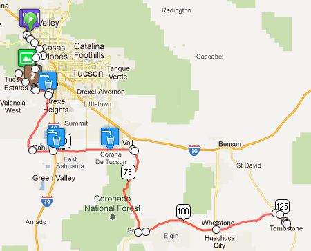
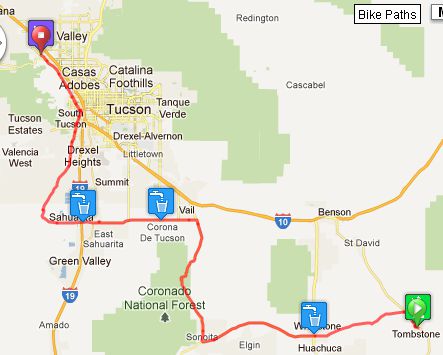
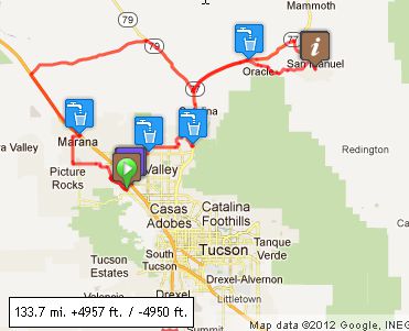
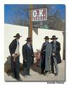
Distance: 374 miles Start time: 6:00 AM. Start location: IHOP, West Cortaro Farms Rd, Marana (See map) Time limit: 40 hours Begin twilight: 6:08 AM Sunrise: 6:32 AM, Sunset: 6:38 PM End civil twilight: 7:02 PM Moonrise: 7:01 PM Moonset: 6:46 AM Sunday; Moon is full. Cost: $10 ACP sanctioned Decription The route for 2012 starts on Cortaro Rd in Marana/Tucson. The first part of the journey is an out and back to Tombstone. The second part is a loop that goes north and east to Oracle and San Manuel. Blow by Blow: First off, we'll climb Gates Pass in Tucson Mountain Park - a virtual saguaro and cactus forest. After that we're only on the streets of Tucson for a short time before entering the Tohono O'odham reservation and traveling past the mines. As we leave Tucson and the reservation behind, we climb over huge rollers from about 2,500 to 5,000 feet above sea level to get to Sonoita. We're in the grasslands now. Not a saguaro in sight, just golden grass and grazing cattle. This is Arizona's wine country. The turnaround is on Allen Street in Tombstone. If you arrive before 5 pm, you'll see people dressed in period clothes and stagecoaches. There are even public hangings on special occasions. Retrace your steps and return to Cortaro Rd in Marana. At this point, you'll be 240 miles into the ride. If you have a hotel room, you can sleep there before continuing to the northern loop. The loop to San Manuel has long rollers to start and then steep up and down rollers as you get into San Manuel, the turnaround. The checkpoint is the post office where you'll mail a post card. After some uphill from San Manuel back to Oracle, the way back turns downhill towards Oro Valley and across the northern part of Tucson, back to start. Overnight Riders are expected to provide their own accomodations. There are several hotels near the start. You will reach these same hotels at 240 miles into the ride (after you come back from Tombstone), so these hotels can be used again as your overnight stop. Download cue sheet Click graphic for on line map. 1. Tucson to Tombstone
2. Tombstone back to Tucson
3. Upper Loop: Tucson to San Manuel and back
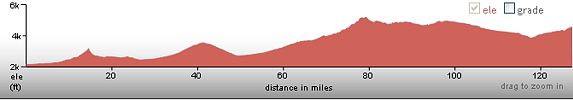
Elevation Profile 1. Tucson - Tombstone
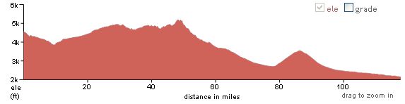
2. Tombstone - Tucson
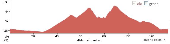
3. Tucson - San Manuel - Tucson
Total: Approx 12,000 feet of climbing.
Lights: Required. There will be a light inspection at check-in to verify front and rear lights are working and are sufficient for night riding. Also required are reflective vest or sash and ankle reflectors. Hydration System: Much of the route is very remote with no services. Check the cue sheet carefully to determine how much water you need to carry to get you to the next water hole. Bob Lynn, El Paso, TX |