Home of Arizona Brevets and Long Distance Cycling
|
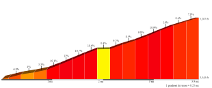
Profile of the Humboldt Climb. Full Image HERE REGISTRATION:
Registration is closed or not yet open. |
| Humboldt Hill Climb |
||||||||
Date: Saturday, December 28, 2024
Distance: 75 miles Start Time: 08:00 Time Limit: 7:56 hours Sunrise: 7:31 AMSunset: 5:29 PM Cost: $10 All riders must pre-register. (No day of event registration.) RUSA sanctioned. WAIVER NOTE: You will be automatically directed to the online waiver after you submit your PayPal payment. If you are not automatically directed to the online waiver after your pay, you may press the "Return to Merchant" button to sign the waiver. The online waiver may also be found at tinyurl.com/AZBrevetWaiver. REGISTRATION NOTE: Once you are registered for a ride, you will see your name in the Registered Riders tab. It may take a day or so for it to appear. Registered riders WILL be sent a "Last Minute Notes" email the day after registration closes, normally the Thursday before the ride. If you do not receive it, please let me know. Also, check your spam folder for the email. RIDE VERIFICATION: All of these events
are sanctioned by Randonneurs USA (RUSA).
As such, all of them will be verified using approved RUSA
methods. Click HERE
to see the details of available options for AZ Radonneurs'
events. Description
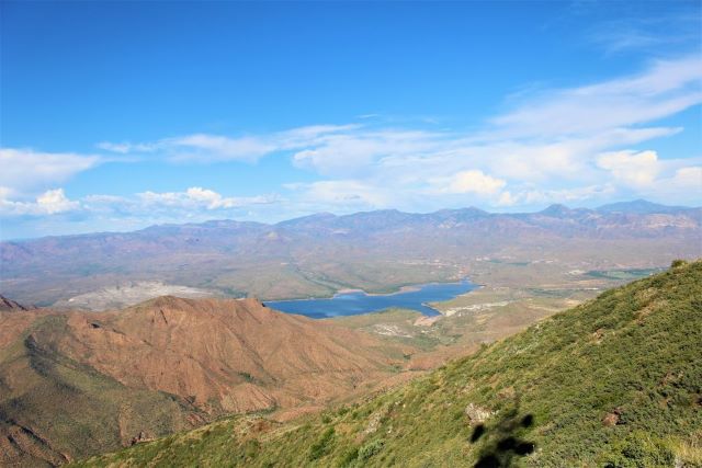
View of Horseshoe Reservoir from the summit. This route is mostly about the Hill Climb. Few cyclists explore Cave Creek Road after the pavement ends. This is a shame because this is one of the best climbs in Arizona! Here's your opportunity to grab a friend or three and ride this iconic climb. Having friends around to share in your suffering will be welcomed! Directions to the start Location: Apache Wash Trailhead, Phoenix Address: 1600 Sonoran Desert Dr, Phoenix, AZ 85085
Cue sheets may be downloaded and printed by riders if they wish. Cue sheets will NOT be passed out at the start. Make sure you have a cue sheet as a backup in case your GPS fails. (Excel sheet is not available.) Elevation Profile
This route climbs roughly 5,500' total feet. There's a steady up-hill to EOP, then the fun begins! 5 miles of hard-packed dirt and 4 miles straight up. What goes up, must come down! Requirements Have fun, be safe, enjoy the ride! Services Services will be noted on the cue sheet and in the RWGPS file, if you choose to download it.
1 Registered Riders.
|