Jul
2
2010
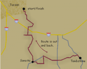
This ride starts at a grocery store at the corner of Houghton and Broadway Blvd on the east side of Tucson.

Ride to Tombstone
Description: Route is out and back. In Tucson we ride on Old Spanish Trail. Down south, we pass through Sonoita and Elgin, Arizona’s wine country. Turnaround is the Old Court House in Tombstone where you can get a good look at the western town.
Distance: 308 km (192 miles)
Services and Checkpoints: Convenience stores every 30 miles. Route is very remote with few services. Take advantage of services when you see them.
Best time to go: October to April.
Most of the route is low traffic roads with no shoulder.
Elevation: Strongly rolling. Total elevation gain is 8,032 feet.
Be the first to review | Region: Grasslands
Jul
2
2010
Starts at the McDonalds/Circle K on Ajo Way in Tucson.
Description: Route is a loop traveling counter clockwise.
Distance: 210 km (130 miles)

The Arivaca Loop
Services and Checkpoints: Convenience stores every 30-40 miles.
Best time to go: October to April.
No freeway riding. Most roads are low traffic.
Elevation: Rolling. Total climbing is 3,410 feet and most of it is in the first half of the ride to Arivaca. After that, it’s mostly downhill.
Be the first to review | Region: Grasslands
Jul
2
2010
Starts at the McDonalds/Circle K on Ajo Way in Tucson.
Description: Route is a loop.
Distance: 206 km (130 miles)

The Arivaca Loop
Services and Checkpoints: Convenience stores every 30-40 miles.
Best time to go: October to April.
No freeway riding. Most roads are low traffic.
Elevation: Rolling. Total climbing is 3,410 feet and most of it is in the first half of the ride to Arivaca. After that, it’s mostly downhill.
Be the first to review | Region: Grasslands


