Arizona Brevet & Randonnee
Home of Arizona Brevets and Long Distance Cycling
|
|
|
Mines to Pines 200 km Brevet |
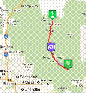
Date: May 5, 2012 Distance: 135 miles. New in 2012! This year we are offering a 200 km version of the Mines to Pines brevet. Start Time: 7 AM. There will be a pre-ride meeting before the brevet for last minute instructions. Start Location: Spring Creek Store on Hwy 188 (about 4 miles north of the junction with Hwy 288 and about 10 miles south of Roosevelt Dam which is at the junction of SR 88 & SR 188) Time Limit: 13.5 hours Sunrise: 6:35 AM Sunset: 20:15 Cost: $10 ACP sanctioned.
The ride starts at the Spring Creek Store along Hwy 188 and travels along the length of Roosevelt Lake. The store is located about 10 miles south of Roosevelt Dam on Hwy 188 and about 4 miles north of the Hwy 288 turnoff. After traveling on Hwy 188, the route then follows SR87, the Beeline Hwy, up Oxbow Hill to Payson. Just north of Payson, the route goes out Houghton Mesa Rd in the pines. The turnaround is at the First Crossing Campground, with the return following the same route back to the Spring Creek Store.
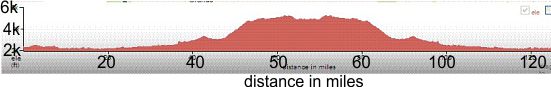
Total climbing 8350 ft! The elevation along Roosevelt Lake is 2175 ft. Starting elevation is 2346 ft. The turnaround past Payson is at 5250 ft. Take note of the route profile as the climbs on this ride are not rollers, but long, steady climbs. This ride passes through several climate zones from 2200 ft at the lake to over 5200 ft elevation in the pines.
Riders are expected to do simple repairs such as repair a flat tire. Lights, safety vest/belt, and ankle bands are required if riding after sunset.
This brevet is definitely more challenging than the Around the Bend 400k brevet in terms of a long climb to Payson. The elevation along Roosevelt Lake is 2175 ft. Starting elevation is 2346 ft. The turnaround past Payson is at 5250 ft. Total climbing 8350 ft! Take note of the route profile as the climbs on this ride are not rollers, but long, steady climbs. This ride passes through several climate zones from 2200 ft at the lake to over 5200 ft elevation in the pines Start/ Finish this year has moved to Hwy 188 below the Salt River Pass climb to eliminate the prior year's big climb out from the Tonto Basin near the end of the route. The store is located about 10 miles south of Roosevelt Dam on Hwy 188 and about 4 miles north of the Hwy 288 turnoff. Checkpoint #2 is at the Tonto Basin Market. Tonto Basin Market is a full grocery store with a deli, pizza & ATM. This is the primary place for food along Hwy 188. Tonto Basin Market closes at 8 pm this year. Butcher Hook Store and Restaurant is farther back from the road than the gas station. The store has a good selection of food, even bananas sometimes. Jake's Corner Store has minimal food. You won't be feasting here, but it may be a life saver if you bonk. Better to plan on Tonto Basin Market. The Highway Rest Area at junction of AZ188 and US87 has NO water or rest rooms this year. Checkpoint #3 is the First Crossing Campground on Houghton Mesa Rd. Checkpoint #4 Tonto Basin Market closes at 8 pm. This is a key place to plan on stopping for food and water as it is a full grocery store with deli and ATM. The Spring Creek Store at mile 135 (finish) closes at 9 pm. They have PowerBars and Clif Bars! Tom Baker is your trail boss for this ride. Brian McGuire, Phoenix, AZ
Carlton van Leuven, Chandler, AZ Charley Anderson, Tucson, AZ Roger Peskett, Tucson, AZ Tom Baker, Tempe, AZ (trail boss)
|
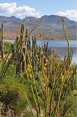
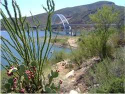
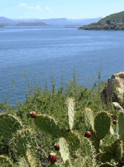 Mines to Pines covers a range of climates and offers diverse scenery on good roads.