Home of Arizona Brevets and Long Distance Cycling
|
REGISTRATION:
Registration is closed. |
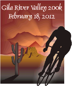
| Gila River Valley |
||||||||||||||||||||||||||||||||||||||||||||||||||||||||||||||||||||||||||||||||||||
Date: Saturday, February 16, 2013
Distance: 125 miles Start Time: 7:00 AM Time Limit: 13.5 hours Sunrise: 6:22 AMSunset: 6:38 PM Cost: $10 All riders must pre-register. (No day of event registration.) ACP sanctioned. WAIVER NOTE: You will be automatically directed to the online waiver after you submit your PayPal payment. If you are not automatically directed to the online waiver after your pay, you may press the "Return to Merchant" button to sign the waiver. The online waiver may also be found at tinyurl.com/AZBrevetWaiver. REGISTRATION NOTE: Once you are registered for a ride, you will see your name in the Registered Riders tab. It may take a day or so for it to appear. Registered riders WILL be sent a "Last Minute Notes" email the day after registration closes, normally the Thursday before the ride. If you do not receive it, please let me know. Also, check your spam folder for the email. RIDE VERIFICATION: All of these events
are sanctioned by Randonneurs USA (RUSA).
As such, all of them will be verified using approved RUSA
methods. Click HERE
to see the details of available options for AZ Radonneurs'
events. Description
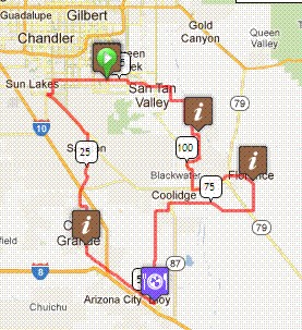
This route circles through the flat valley irrigated by the Gila River. The two Gila River crossings on the route are normally dry, as the Gila has been diverted into a canal just East of our route near Florence. On our route on the Florence-Kelvin Highway, we cross two canals that carry Colorado River and Gila River water side by side! This route uses many of the roads south of the East Valley that cyclists often ride. On this ride, we will pass through Queen Creek, Gilbert, Chandler, Sacaton, Casa Grande, Eloy, 11 Mile Corner, Coolidge and Florence. Directions to the start Location: Town of Gilbert, corner of Power and Chandler Heights Address: Shopping center at the intersection of Power and Chandler Heights Rd in Gilbert
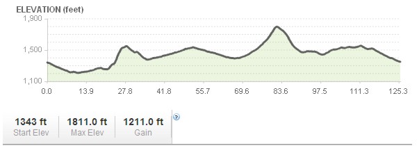
Cue sheets may be downloaded and printed by riders if they wish. Cue sheets will NOT be passed out at the start. Make sure you have a cue sheet as a backup in case your GPS fails. Elevation Profile
1,200 feet accumulated feet Requirements Riders are expected to do simple repairs such as repair a flat tire. Lights: Optional. However, if you're still riding after sunset, you need lights as required by law. Services There is food and restrooms in Bashas grocery store at the start. In Casa Grande: Fry's plaza at Pinal Ave & McCartney In Eloy, Coolidge and Florence: Circle K 20 Registered Riders.
|